
Can I help at sea?
A proposal to help during a nautical emergency.
Can I help at sea?
This is another idea that came from writing fiction. We are submitting this one to the Meta Community Forums Ideas Board. We’ll let you know if we get any nibbles or kudos as they call them on this board.
Feature Idea: Maritime Navigation Assistance Through AR
What if the person who knows how to navigate suddenly can't?
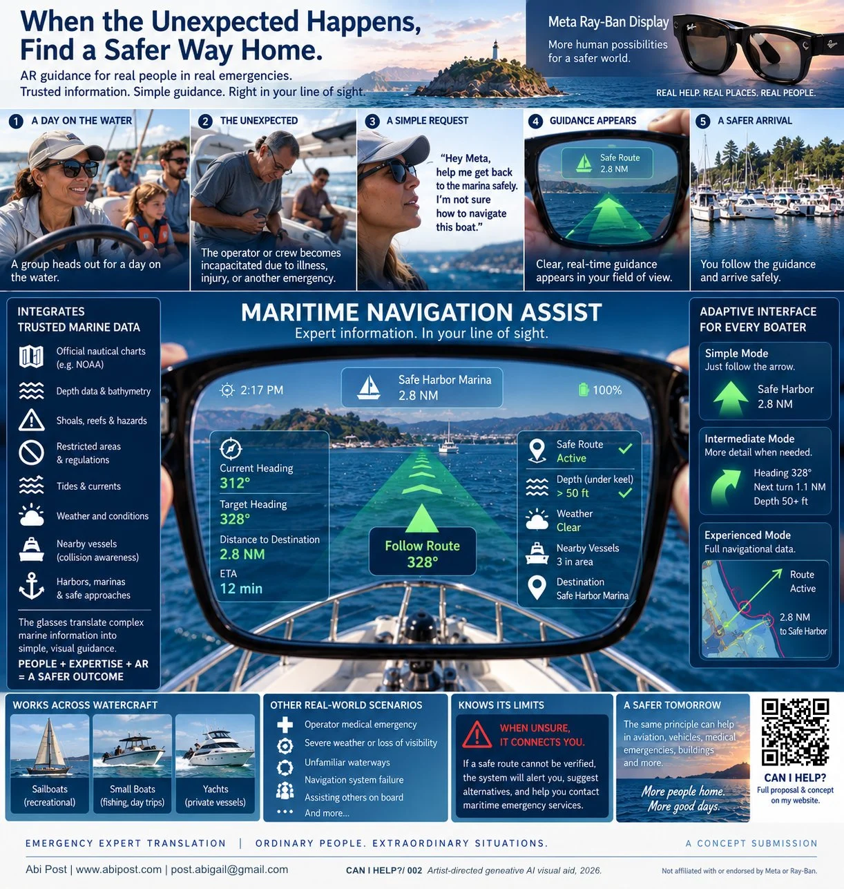
Imagine a group of friends or family spending a day on the water in a recreational boat.
The person operating the vessel becomes incapacitated by illness, injury, or another emergency.
Someone else aboard is capable of operating the basic controls, but has little or no navigational experience.
The boat works. Their phone works. GPS works. Marine navigation information exists.
The problem is that the person now responsible for getting everyone home may have no idea how to turn that information into a safe course.
Could Meta Ray-Ban Display help bridge that gap?
A passenger might say:
“The operator is sick. I don't know how to navigate this boat. Help me get to a safe harbor.”
Instead of attempting to teach someone marine navigation during an emergency, the glasses could help translate established marine-navigation information into simple guidance directly in the user's field of view.
Not simply an arrow toward land
The simplest version sounds easy:
SAFE HARBOR →
But marine navigation is not simply a matter of pointing toward a destination.
A straight line toward shore could cross shallow water, rocks, reefs, shoals, restricted areas or other hazards.
A serious implementation would therefore need to draw from established and authoritative marine-navigation sources.
Depending on available systems and data, that could include:
Official nautical charts
Coastlines, channels, navigational aids and charted hazards.
Depth and bathymetric information
Helping determine whether a route is appropriate for the vessel.
Shoals, reefs, rocks and underwater hazards
Restricted and regulated areas
Tides and currents
Marine weather and changing conditions
Nearby vessels and collision information, where reliable vessel-position information is available.
Harbors, marinas and safe approaches
The glasses shouldn't invent a route because the destination happens to be visible on the horizon.
They could instead become a new interface to navigation information that already exists.
Translate navigation into something a non-expert can understand
Imagine that an established navigation system determines that the appropriate safe course is 328°.
A conventional display might tell the user:
TARGET HEADING: 328°
Someone unfamiliar with navigation may still reasonably respond:
Fine. What do I actually do?
The glasses could translate the same information into the user's field of view:
TURN RIGHT →
As the vessel turns:
KEEP TURNING →
And when it reaches the appropriate heading:
328° ✓
HOLD THIS COURSE
The user doesn't necessarily need to understand bearings.
They need to understand the arrow.
Show less, not more
As with an aviation emergency, the goal shouldn't be to reproduce an entire marine chart in front of someone's eyes.
A frightened or inexperienced operator needs the information that matters now.
The simplest interface might show:
SAFE ROUTE ACTIVE ✓
SAFE HARBOR: 2.8 NM
→ FOLLOW ROUTE
Additional information could appear only when necessary:
DEPTH AHEAD: SAFE ✓
WEATHER: CLEAR ✓
NEARBY VESSEL
COURSE CORRECTION →
Someone with boating experience could choose a more detailed display showing headings, waypoints, depth, weather, traffic and chart information.
The same system could therefore provide different levels of information for different users.
Use authoritative sources
For a safety-critical application, consumer AI shouldn't independently decide that a particular route is safe.
A serious implementation could instead establish a hierarchy:
Established marine-navigation systems and charts → route and hazard information
GPS and vessel systems → authoritative position and vessel information where available
Marine weather and traffic services → environmental and collision information
Maritime emergency services → expert human assistance when required
Meta Ray-Ban Display → translation into simple visual and spoken guidance
The interesting capability isn't replacing marine-navigation systems.
It is making their information usable by someone who may never have learned to read them.
Know when not to navigate
This may be one of the most important parts of the concept.
Sometimes there will not be enough reliable information to establish a safe route.
Perhaps GPS is unavailable.
Perhaps weather conditions have deteriorated.
Perhaps the system doesn't know the vessel's draft.
Perhaps chart or depth information is insufficient.
Perhaps the situation simply requires professional assistance.
The glasses should never manufacture confidence.
Instead:
SAFE ROUTE CANNOT BE VERIFIED
REDUCE SPEED
CONNECTING TO MARITIME EMERGENCY SERVICES
The system could also make one piece of information immediately available:
YOUR POSITION
33° XX.XXX' N
118° XX.XXX' W
SHARE THIS POSITION WITH RESCUE SERVICES
Sometimes getting help to the boat is safer than trying to get the boat home.
Useful beyond an emergency
The same interface could also help in much more ordinary situations.
A recreational boater becomes disoriented in unfamiliar waters.
Someone encounters unexpected fog or poor visibility.
A passenger assists an experienced operator during an emergency.
A boater needs to identify the nearest appropriate harbor.
Someone needs help understanding an unfamiliar navigation system.
An experienced boater might use the glasses as a heads-up display for route, heading, depth, weather or nearby-vessel information while continuing to look at the water ahead.
And the concept could work across very different kinds of recreational watercraft.
The interface doesn't necessarily need to know whether the person owns a yacht.
It needs to know what information will help them get home safely.
Emergency Expert Translation
The maritime and aviation examples suggest a larger possibility for AR.
What happens when an ordinary person suddenly has to interact with a system they don't understand?
On the water:
SAFE COURSE →
In an aircraft:
PRESS THIS ↓
During a medical emergency:
AED LOCATED →
During a building emergency:
SAFE EXIT →
Rather than asking AI to replace the expert, AR could help connect people to authoritative expertise and translate it into the physical world around them.
Identify the situation.
Use trusted information.
Translate it into the person's field of view.
Show one safe action at a time.
For maritime navigation, that might ultimately mean taking something as complicated as charts, headings, depth, currents, weather and vessel traffic and answering the question the person at the controls actually needs answered:
Which way can I safely go?
Thank you for considering the idea,
I remain,
Abi Post
www.abipost.com